Farm + Hunting  /  v2
SkyGrain  /  Tactical Property Intelligence for Outfitters
SkyGrain aerial to isometric scale transition - hunting property overview

SkyGrain  /  Tactical Property Intelligence

SkyGrain.
Pre-mission briefings
for the hunt.

Drone photogrammetry fused with USGS, FEMA, NOAA, USDA, and trail-cam data into a tactical view of the property. Built for high-dollar outfitters who run guided hunts like operations, not weekends.

Aerial photos show what the land looks like. SkyGrain shows what the hunt looks like.

High-dollar outfitters in the Illinois / Iowa / Missouri whitetail corridor run guided hunts as professional operations. They charge $4K to $12K a week per client. Their clients arrive with expectations set by Instagram reels and broadcast hunting content. What lands in front of those clients today is a clipboard, a photocopied aerial, and a verbal walkthrough at the lodge. The delivery does not match the price tag.

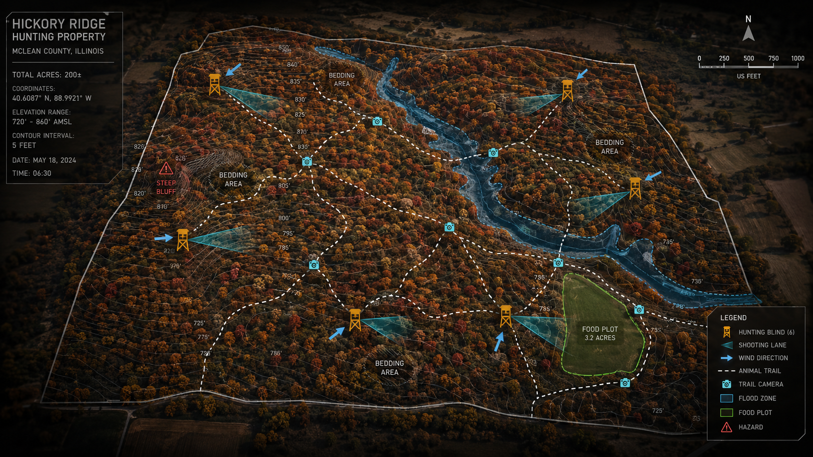
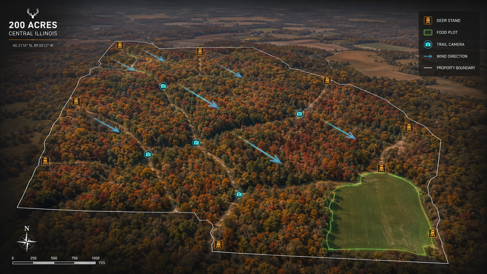
The intelligence to do better already exists. USGS publishes elevation. FEMA publishes flood zones. NOAA publishes wind history. USDA publishes soil data. Trail cameras stream activity. The outfitter has all of it on a property they have hunted for fifteen years. None of it is fused. None of it sits on one screen. None of it tells a client a story about the morning they are about to walk into.

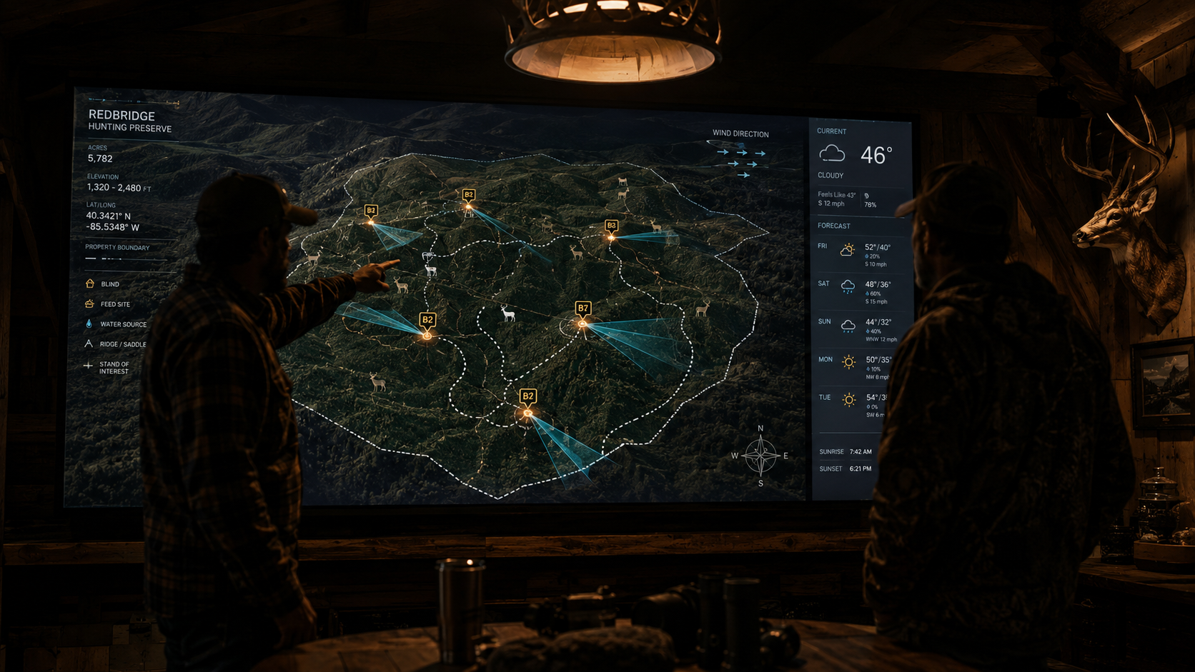
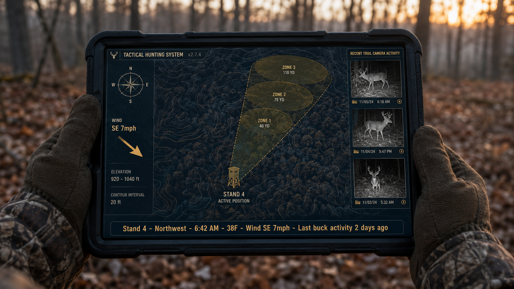
That fusion is the SkyGrain product. A georeferenced 3D mesh of the property serves as the spatial substrate. Every other data layer pins to it. The output is operations-grade situational awareness rendered as something a guide can pull up at the truck and a client can study at the lodge bar the night before. Nobody in this segment is selling it. Outfitters are about to want it.

Intelligence-grade property awareness. One screen, every layer that matters.

Tactical property briefing master map - hunting blinds, sightline cones, animal trails, wind arrows, elevation contours, flood zones, trail camera positions over 3D terrain
Tactical Property Briefing - the master view. Amber blind positions with directional sightline cones. Dashed animal trails threading from bedding to food plot. Wind arrows per stand. USGS contours, FEMA flood zone, hazard markers, trail camera positions, all keyed to the photogrammetry mesh. The same idiom a tactical operations center uses, applied to 200 acres of whitetail country.
Photogrammetry Spatial Substrate
DJI Mini 3 double-grid mission at 40m AGL, 80/70 overlap. Georeferenced 3D mesh of the full property: terrain, timber canopy, water features, structures, access roads. GSD ~1.1 cm/pixel. This is the foundation every other data layer pins to.
Multi-Source Intelligence Fusion
USGS elevation contours at 5-foot intervals. FEMA flood zones around creek and low ground. USDA soil composition for food-plot planning. NOAA wind history per stand position. Hazard markers on bluff edges and steep slopes. Eight data sources, one fused view.
Hunting Operations Overlay
Blind positions with directional sightline cones. Animal trail paths between bedding, food, and water. Trail camera positions with linked recent activity. Predominant wind per stand against NOAA data. Bedding areas, mineral sites, food plot polygons - the operational vocabulary of the hunt.
Briefing-Ready Delivery Surface
Hosted viewer link - works on iPad in the field, wall display at the lodge, desktop in the office. No app install. Print-resolution tactical map for the truck. Annual re-flight refreshes the mesh and the overlay so the intelligence stays current as the property changes.

The Intelligence Stack

Eight data sources, one fused tactical view.

SkyGrain's edge is not the drone footage. The drone is the substrate. The edge is what we layer on top - public data, sensor data, and hunting-specific overlays, all geo-locked to the same property mesh.

Substrate
Drone Photogrammetry
DJI Mini 3 georeferenced 3D mesh, ~1.1 cm/pixel.
USGS
Elevation Contours
5-foot intervals across the full property terrain.
FEMA
Flood Zones
Creek floodplain and low-ground polygon overlays.
USDA
Soil Composition
For food plot planning, cover crop, and habitat work.
NOAA
Wind & Weather History
Predominant wind patterns mapped to each stand.
Safety
Hazard Markers
Bluff edges, dropoffs, hazardous slopes called out.
Sensor
Trail Camera Integration
Recent activity pinned to camera position on the map.
Tactical
Hunting Overlays
Blinds, sightline cones, animal trails, bedding, food, water.

Pre-hunt brief, in-hunt reference, post-hunt debrief.

The product is not a deliverable that sits on a shelf. It is an operational tool that shows up at four moments across the hunt. Each moment is a touchpoint the client sees - a reminder of what the outfitter is delivering, and a reason the engagement renews next season.

DJI Mini 3 drone flying photogrammetry mission over hunting property at golden hour Capture
Property Capture
Part 107 licensed pilot flies the photogrammetry mission. Insta360 X5 ground walk covers blinds, access routes, food plots, water sources. One site visit, full data package same day. Scheduled around the off-season so the property is undisturbed.
Mesh
USGS
FEMA
NOAA
Overlay
QA
Fuse
Data Fusion
Polycam cloud processing produces the mesh. USGS contours, FEMA flood zones, USDA soil, NOAA wind history layered on top. Outfitter's blinds, trail cam positions, animal pattern intel pinned to real coordinates. Hazard markers placed and QA'd.
Outfitter lodge briefing room with mounted tactical display showing hunting property map - guide briefing a client pre-hunt Deploy
Briefing Surface
Hosted viewer drives the lodge display, the guide's tablet, the client's phone. Same data, three surfaces. Annual re-flight refreshes the mesh and the overlay each off-season so the briefing stays accurate as the property and the patterns evolve.
Moment One
Pre-Hunt Briefing at the Lodge
Guide pulls up the tactical view on the lodge display. Walks the client through their blind, the prevailing wind, the trail cam activity from the last 48 hours, the access route in. Sets the expectation, builds the anticipation, signals a professional operation.
Moment Two
In-Hunt Reference in the Field
Guide's tablet carries the same view to the blind. Wind shifts mid-morning, the guide reads the NOAA-anchored wind layer and re-routes the afternoon stand. Live position shared with the client. The plan adapts because the intelligence travels with the hunt.
Moment Three
Post-Hunt Debrief
Review the morning spatially. Where was the deer first spotted, what trail did it take, where did the shot connect, what did recovery look like. The debrief becomes part of the client's record of the hunt and feeds the planning for next year's return visit.
Moment Four
Annual Property Refresh
Quarterly or annual recapture tracks land changes, food plot performance, animal pattern drift year over year. The outfitter's intelligence library compounds. The engagement renews. The recurring revenue is in the calendar, not the cold call.

What a 200-acre central Illinois briefing actually looks like.

Aerial 3D hunting property map, 200 acres Central Illinois, deer stand markers, food plot overlay, terrain legend
200 acres, central Illinois. Annotated stand positions, food plots keyed to real terrain, readable legend in the corner. This is the briefing surface - not an aerial photograph, not a laminated map, but the operational view an outfitter walks a client through the night before opening day.
The intelligence layer is what justifies the price tag of a guided hunt.

A client paying $8K for a week of guided whitetail does not want a clipboard at the lodge. They want to feel the production values of the operation match what they are paying. The tactical briefing is the most visible artifact of a professional outfit. It signals that the guide knows the property in detail, has thought about wind, has read the trail cam patterns, has a plan for each morning and a plan for when the plan changes.

For the outfitter, the operational value runs deeper. A new guide can study the property before opening day. Stand assignments get made over coffee, not in the parking lot. Wind shifts get re-routed against the NOAA layer instead of guessed at. Post-hunt debriefs become part of the client's record. The intelligence compounds across the season and across the years.

No competitor in this region is delivering the fusion. Aerial photographers sell photos. Northwoods Mapping sells static prints. In-house brokerage drone programs sell flyovers. SkyGrain sells the briefing - the same operations-grade situational awareness an organized operation runs on, scaled to a hunting lease.

Retainer model. Annual recapture. Multi-property packages for serious operations.

Rugged tablet held in a hunter's gloved hands at dawn showing tactical view of a single blind position - sightline cones, wind direction, elevation contours, trail cam thumbnails
Stand 4, Northwest, 6:42 AM, 38F, Wind SE 7 mph. This is the screen the guide carries to the blind. Sightline cone, wind arrow, local terrain contours, recent trail cam thumbnails, last buck activity. The recurring fee is not for a static map - it is for the intelligence surface that travels with the hunt and refreshes every season.
$2,000 – $4,000
initial property build + $800 to $1,500 per year for recapture and intelligence refresh

The economics are built around outfitters running guided hunts at $4K to $12K per client per week. At those rates, a $2K to $4K property build amortizes across the first season's clients. The recurring $800 to $1,500 annual refresh is a line item, not a debate. Multi-property outfitters running three or more leases get a packaged discount that turns SkyGrain into the standing intelligence vendor for the operation rather than a one-off engagement. The premium-client briefing becomes a differentiator the outfitter can sell back to their own clients as part of the booking package.

Single Property Build
$2,000 - $4,000 initial, full mesh + intelligence stack + overlay
Annual Refresh Retainer
$800 - $1,500/yr quarterly or annual recapture + overlay update
Multi-Property Package
3+ leases, blended rate, single point of contact for the operation
Client-Facing Resale
Premium briefing positioned as a differentiator in outfitter booking packages

You know a high-dollar outfitter. I have the intelligence product. Let's find out if it fits the operation.

If you have a line into a guided-hunt outfitter running serious operations in the Illinois / Iowa / Missouri corridor - the kind charging $4K to $12K a week per client - that introduction is the entire ask. SkyGrain does not need a capital raise or a partnership term sheet. SkyGrain needs the first lodge to put the tactical view on the wall and the first guide to carry it to the blind.

If you are that outfitter, the proposal is direct. Let me build the intelligence layer on one of your properties this off-season at cost. I bring the drone, the data fusion, the hosted viewer. You get a briefing surface you can put in front of next season's clients before they ever set the deposit. If it changes how your clients perceive the operation, year two becomes a paid retainer. If it does not, you walked away with a better property dataset than you had and nobody owes anybody anything.

Year 1 success looks like two or three outfitter relationships on the retainer model. From there the recurring intelligence-vendor structure either compounds or it does not, and the data tells us which.

Pattern One
Quarterly / Annual Recapture
Each property on the retainer gets a scheduled refresh. The intelligence stays current as the land and the patterns change season over season.
Pattern Two
Multi-Property Packages
Outfitters running three or more leases consolidate to a packaged rate. SkyGrain becomes the standing intelligence vendor for the whole operation.
Pattern Three
Client-Facing Differentiator
The premium-client briefing is something the outfitter resells in their booking package - a visible production value that justifies the rate card.

Spatial AR field reference. Year-over-year change detection. The intelligence library compounds.

Apple Vision Pro spatial walkthrough of a hunting property terrain model - AR field reference and pre-season scouting use case
The tactical view follows the guide into the woods.

The same photogrammetry mesh that drives the lodge display is the substrate for spatial AR field reference. ARKit Geo Tracking runs today on captured outdoor spaces. Phone AR or Vision Pro can anchor the sightline cones, the animal trails, the wind arrows on the actual terrain in front of the guide. The intelligence stops being a screen the guide checks. It becomes a layer the guide sees through. The hardware stack exists today. What is missing is the captured spatial data library - and that is what the recurring recapture model builds.

The same library unlocks year-over-year change detection. This season's terrain compared to last season's. Trail cam activity patterns drifting toward the new food plot. Bedding areas shifting after the timber thin. Flood line creeping a hundred feet further into the bottoms after a wet spring. The first capture is a snapshot. The third capture is a trend. The fifth capture is institutional memory the outfitter could not have produced any other way.

The long-term value is the intelligence library, not the individual deliverable. A multi-year, multi-property spatial dataset of working hunting land in a proven whitetail region, with active recurring customers paying for the refresh - that is an asset an enterprise mapping or outdoor-tech acquirer buys rather than builds.