Real Estate
SkyGrain  /  Rural, Acreage & Niche Residential
SkyGrain aerial to isometric scale transition - property spatial model overview

SkyGrain  /  Spatial Computing Services

SkyGrain.
Spatial truth for
properties that matter.

Drone photogrammetry, 360 capture, and interactive spatial models for listings where the exterior is the story. Rural acreage, lakefront, equestrian, and custom architecture.

Matterport owns interior dollhouses. Nobody owns the exterior for properties where the land is the listing.

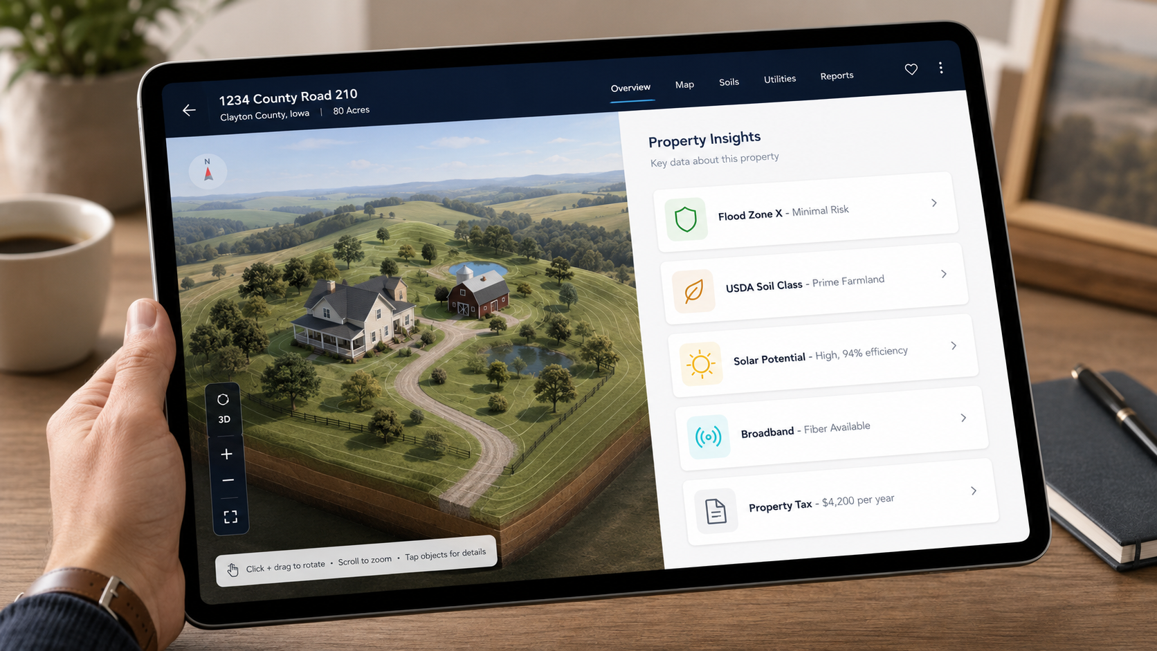
Matterport has 6 million indoor scans in their library. They are the dominant product for standard residential real estate photography - interior walkthroughs, room-by-room dollhouse views, floor plan exports. That market is theirs and they have earned it. But Matterport is interior-only by design. They do not capture the 40-acre lot, the creek frontage, the mature timber, the view corridor, the outbuildings, the road access, the wetland setbacks. For properties where buyers are buying the land as much as the structure, Matterport is not the right tool. There is no right tool yet. That is SkyGrain's entry point.

The 2024 NAR settlement changed the commission conversation in a specific way. Buyers' agent commissions are now openly negotiable for the first time in decades. Agents who differentiate on listing quality have a real argument in that conversation: a spatial model of the full property is a concrete deliverable that sellers can point to. It is not a luxury add-on - it is a legitimate value-of-service item. For rural, acreage, lakefront, equestrian, and custom architecture listings, where the exterior is a primary driver of value, a precise 3D model of the property is a stronger marketing asset than any combination of photos currently on the market.

The competitive landscape is honest: nobody is currently delivering exterior-first spatial models for niche residential listings at a price point agents can absorb per engagement. That gap is real and it is not going to stay empty indefinitely. SkyGrain's advantage is being early in a specific regional market where the listings are already there and the brokers are already known.

One capture session. Four layers. The full property, not just the rooms.

Isometric cutaway with property features overlay - the SkyGrain residential deliverable
Isometric cutaway with property feature overlay. For niche residential: lot boundary, outbuildings, water features, setback zones, view corridor annotations, and improvement records. The exterior reads clearly in a single view - no mental rotation required, no guessing at what the photo is not showing.
Drone Photogrammetry Exterior
DJI Mini 3 double-grid mission at 40m AGL, 80/70 overlap. Georeferenced 3D mesh of the full property: structure, terrain, water features, outbuildings, access roads, lot boundary. GSD ~1.1 cm/pixel. The land model Matterport does not produce.
Isometric Cutaway - Interior + Exterior
Walls-above removed, 3/4 perspective rendering. Every room, doorway, and outdoor feature visible from one angle. Matterport does the dollhouse. SkyGrain adds the property context: the lot, the setbacks, the outbuildings, what sits outside the walls.
360 Ground-Level Capture
Insta360 X5 at 8K/72MP. Interior rooms, exterior feature areas, outbuildings, access points, and view corridors. Pinned to real coordinates as navigable spheres in the 3D model. Buyers can walk the property remotely before requesting a showing.
Property Data Layer
FEMA flood zone, USDA soil classification, assessor records, and lot boundary auto-populated from public sources and overlaid on the spatial model. Data that matters to rural buyers, visible in context on the property itself.

Listing to delivered spatial model in three steps.

DJI Mini 3 drone flying photogrammetry mission over residential property at golden hour Step 1
Capture
Part 107 licensed pilot flies the exterior photogrammetry mission. Insta360 X5 ground walk covers interior rooms and exterior feature areas. One site visit, typically under two hours. Full data package same day.
Mesh
Ortho
Points
360
Data
QA
Step 2
Process
Polycam cloud processing produces the 3D terrain mesh and orthomap. Isometric cutaway rendered. FEMA flood zone, USDA soil, and assessor records auto-populated. Property data overlay keyed and positioned. Viewer configured for MLS embed.
Command center display showing spatial model - same delivery architecture for listing page embedding Step 3
Deliver
Hosted viewer link - embed code for any MLS listing page, agent website, or listing portal. No app install. Works on iPad, desktop, and mobile. Agent receives the link and the print-quality orthomap for the listing package.

What the agent's listing deliverable looks like to a buyer.

iPad showing FSBO property listing with 3D exterior model, address bar visible, property data dashboard, full UI
b6 selected over 6: visible address bar, more complete UI, and a more convincing buyer-facing view of what the spatial model looks like as a listing deliverable. This is what the buyer sees when the agent drops the link into a showing communication.
The buyer sees the whole property before they request a showing.

Rural buyers and acreage buyers make decisions differently than buyers shopping generic suburban inventory. They are evaluating drainage patterns, timber density, setback distances, view corridors, road access, and the relationship between the structure and the land. Standard listing photos do not communicate those things. A spatial model does.

For an agent representing a 15-acre equestrian property, a 40-acre lakefront parcel, or a custom home on 5 acres with outbuildings and a creek, the SkyGrain spatial model is the listing's most useful document. It reduces no-show showings from buyers who did not understand the property layout, and it increases serious inquiry from buyers who understood it and decided they wanted to see it in person. That has direct value to an agent's conversion rate on listings where showings are expensive in time and coordination.

The 2024 NAR settlement created a window where agents need to justify their commission in concrete terms. A spatial model of the full property is a concrete, visible deliverable - not a claim about service quality but an actual artifact the seller can point to. That is worth something in the current environment.

Per-listing pricing. Volume opportunity with active agents.

$200 – $2,000
per listing, depending on acreage and deliverable depth

A standard rural residential listing with drone exterior plus 360 interior plus hosted viewer anchors at $200 to $400. Full package with isometric cutaway, property data layer, and print orthomap for a 20-plus-acre parcel runs $800 to $2,000. The economics work for an agent who is listing 10 to 20 niche properties per year - that is a marketing line item, not a luxury. For agents specializing in rural, acreage, or waterfront properties, a preferred-vendor arrangement with consistent pricing and reliable turnaround is the volume conversation worth having.

Standard Listing
$200 - $400 for rural residential with drone exterior + 360 + hosted viewer
Full Acreage Package
$800 - $2,000 with isometric cutaway, data layer, and print orthomap
Matterport comparison
Interior only. No exterior terrain, no lot boundary, no property data. Different product entirely.
Volume path
Preferred-vendor arrangement for agents doing 10+ niche listings per year

If this is your market, let's talk about one listing as a trial.

If you specialize in rural, acreage, lakefront, equestrian, or custom residential listings in central Illinois, you already know which of your current listings would benefit most from a spatial model. The exterior is the story on those properties, and you know it - that is why you took the listing. The question is whether the deliverable is compelling enough to justify adding it to your listing process.

The ask is straightforward: let me run the product on one of your active listings at a reduced cost or at cost. You get a spatial model you can use in your marketing. I get a real listing to use as a portfolio demo and a real-world test of the agent workflow - scheduling, turnaround, deliverable format, how it integrates with your listing page. If it works for you on listing one, we talk about what a preferred-vendor arrangement looks like going forward. If it does not fit your workflow, you have a better marketing asset than you had before and we part on good terms.

Not asking for a commitment. Asking for one listing where we can both find out if this works in practice. If you know an agent who fits this profile better than you do, that referral is equally valuable - I am looking for the right first customer more than I am looking for volume right now.

The spatial model powers the agent listing today. Down the road it powers more.

Apple Vision Pro spatial walkthrough of a property model - future-state buyer experience
Spatial walkthrough for buyers before they book the showing.

The same photogrammetry mesh that creates the agent's listing deliverable is also the substrate for Apple Vision Pro spatial walkthroughs. ARKit Geo Tracking runs on captured outdoor spaces today. A buyer with a Vision Pro headset can walk a 40-acre property spatially before booking a showing - ground level, drone altitude, isometric cutaway view, all from the same captured mesh. That is not a product SkyGrain is selling today, but it is not science fiction either. The spatial data is the foundation.

There is also a longer-term platform angle - when the same content that powers an agent's MLS listing can power a seller-direct experience, the captured spatial model becomes a more durable asset than a listing photo. That is a Phase 4 conversation, not a current pitch. This flyer is for agents. The platform reframe is worth noting as a future direction because it shapes the data architecture decisions being made now.

Year 1 is proving the per-listing product works for agents on the kind of listings where exterior is the story. That proof, done cleanly, is what opens the next conversation.